


وصف لـ Mobile Topographer Free
Your mobile Topographer!
The leading tool for the professional surveyor or anyone who wants to mark his property, offering the best accuracy and extensive functionality that no other app can!
*** Increase GPS accuracy using:
- Weighted averaging (on every axis).
- Map calibration.
- Device calibration on map, or on a know point.
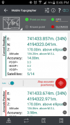
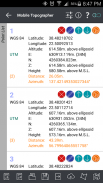
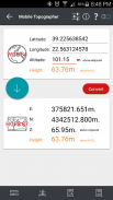
*** Display and convert GPS geodetic to Cartesian EN coordinates and back:
- UTM.
- Europe ETRS89/UTMZ28-38.
- Hellas HGRS 87 (EGSA 87).
- Hellas HGRS 87 - HEPOS.
- Hellas HTRS07/TM07.
- Iceland ISN93/Lambert 93.
- Morocco Merchich.
- SPCS83 (124 zones) USA.
- Romania S-42(58)/Stereo 70.
- Lebanon & Syria Deir ez Zor/Stereo.
- Croatia HTRS96/TM.
- Serbia SRB-ETRS89/UTM, SRB-MGI/Z7.
- Australia MGA94 (GDA94), AMG66 (AGD66) National, A.C.T., Northern Territory, NSW & Victoria, Tasmania,AMG84 (AGD84).
- Former FR of Yugoslavia MGI Balkans zones 5,6 & 7.
- Italy Monte Mario West Zone 1 Peninsular, West Zone 1 Sardinia, East Zone 2 Peninsular, East Zone 2 Sicily.
- Costa Rica CΜ05/CRTM05, Ocotepeque 1935 Costa Rica Norte & Ocotepeque 1935 Costa Rica Sur.
- Cyprus CGRS-93-LTM.
- Hungary HD72/EOV.
- Kosovo KosovaREF01.
- Latvia LKS92/TM.
- Lithuania LKS94/TM.
- Spain ED50/UTMZ29-30 NW, ED50/UTMZ29-31 ML & ED50/UTMZ31 BA.
- Uk's OSTN02/OSGM02.
- Turkey ED50/Gauss-Kruger 3° Z9-15, ITRF96 & ED50/UTMZ35-38.
- Luxembourg LUREF.
- Venezuala REGVEN/Z18-20.
- Sweden SWEREF99 TM.
- Argentina POSGAR 94 & POSGAR 2007.
- India Kalianpur 1975 ZI - ZIV.
- Algeria Nord Sahara 1959 / Z29-32.
- Armenia, Georgia, Azerbaijan, Estonia, Latvia, Lithuania, Russia - Kaliningrad and Kazakhstan Pulkovo 1942/ CS63 (A)Z1-4, (C)Z0-2, (K)Z2-4.
- Central and South America SIRGAS 2000.
- Nigeria and Cameroon Minna 1996 & 2008 MTM West, Mid, East Belts & UTM Z31-33.
- Bangladesh Gulshan 303/TM.
- France RGF93/CC42-50.
- Canada CSRS
- Egypt 1907 Blue, Red, Purple, Extended Purple belts.
- Portugal ETRS89/PTM06.
- Netherlands Amersfoort/RD new.
- Qatar QND95.
- Colombia MAGNA-SIRGAS Far West, West, Bogota, Central East, East zones.
- Mexico ITRF 2008/LCC.
- Madagascar Tananariva (Paris)/Laborde & Tananariva/UTM Z38-39S .
- Tunisia Carthage (Paris)/Mining Grid, Carthage/Nord, Carthage/Sud, Carthage/TM 11 NE, Carthage/UTM zone 32N.
- Liechtenstein CH1903/LV03C-G.
- Switzerland CH1903/LV03 (old), CH1903+/LV95 (new).
- Brazil SAD69/UTM Z18-25 & SAD69(96)/UTM Z18-25
- Spain Canary Islands REGCAN95/LAEA & REGCAN95/LCC & REGCAN95/UTM Z27-28
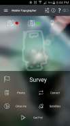
*** Auto stop for accurate positioning.
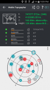
*** Examine the satellites above you in a sky view.
*** Signal strength and number of satellites indication for each GNSS constellation individually.
*** Multiple units support:
- Meters,
- International feet,
- US survey feet.
***Height calculation:
- Ellipsoidal height.
- EGM96 orthometric height calculation.
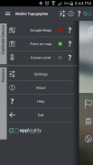
*** Convert from geodetic to Cartesian coordinates and back:
- Support for device measured points, or
- Manually input of geodetic or Cartesian coords.
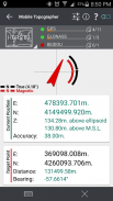
*** Drive me:
- Key in coordinates of the target point in either geodetic or Cartesian coordinates, or select a point from the list and follow the pointer.
- Compass indicating both magnetic and true North.
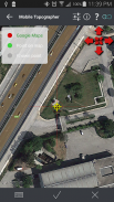
*** Project on Map:
- Project individual points on any map application.
- Project list of points, and the defined polygon, on embedded maps.
*** Save multiple point lists, to use them later.
*** Calculate area.
*** Export point lists το:
- .txt (text file)
- .csv (point file - comma separated)
- .kml (google earth file)
- .gpx (Gps Exchange format)
- .dxf (drawing file)
*** Send file via e-mail, or upload it to cloud.
*** Complete help text support.
Help us improve Mobile Topographer by e-mailing your comments and suggestions.
TAGS: Survey Surveyor Property GPS GNSS GLONASS QZSS BEIDOU GALILEO
الطوبوغرافي المحمول الخاص بك!
الأداة الرائدة لمساح المهنية أو أي شخص يريد للاحتفال ممتلكاته، وتقديم أفضل دقة وظائف واسعة النطاق التي لا يمكن لبرنامج آخر!
*** زيادة دقة تحديد المواقع باستخدام:
- المتوسط الموزون (على كل محور).
- خريطة المعايرة.
- معايرة الأجهزة على الخريطة، أو على نقطة المعرفة.
*** العرض وتحويل نظام تحديد المواقع الجيوديسية لالديكارتي EN ينسق ومرة أخرى:
- UTM.
- أوروبا ETRS89 / UTMZ28-38.
- هيلاس HGRS 87 (EGSA 87).
- هيلاس HGRS 87 - HEPOS.
- هيلاس HTRS07 / TM07.
- أيسلندا ISN93 / لامبرت 93.
- المغرب Merchich.
- SPCS83 (124 المناطق) الولايات المتحدة الأمريكية.
- رومانيا S-42 (58) / ستيريو 70.
- لبنان وسوريا دير الزور / ستيريو.
- كرواتيا HTRS96 / TM.
- صربيا تعتبر الدار-ETRS89 / UTM، تعتبر الدار-MGI / Z7.
- أستراليا MGA94 (GDA94)، AMG66 (AGD66) الوطنية، A.C.T.، الإقليم الشمالي، نيو ساوث ويلز وفيكتوريا، تسمانيا، AMG84 (AGD84).
- FR السابق مناطق يوغوسلافيا MGI البلقان 5،6 و 7.
- إيطاليا ماريو مونتي الغربية منطقة شبه الجزيرة 1، المنطقة الغربية 1 سردينيا، المنطقة الشرقية 2 شبه الجزيرة، المنطقة الشرقية 2 صقلية.
- كوستاريكا CΜ05 / CRTM05، أوكوتبيك 1935 كوستاريكا نورتي وأوكوتبيك 1935 كوستاريكا سور.
- قبرص CGRS-93-الأشهر الاثني عشر الأخيرة.
- المجر HD72 / EOV.
- KosovaREF01 كوسوفو.
- لاتفيا LKS92 / TM.
- ليتوانيا LKS94 / TM.
- إسبانيا ED50 / UTMZ29-30 NW، ED50 / UTMZ29-31 ML & ED50 / UTMZ31 مكتبة الإسكندرية.
- المملكة المتحدة في OSTN02 / OSGM02.
- تركيا ED50 / غاوس-كروجر 3 ° Z9-15، ITRF96 وED50 / UTMZ35-38.
- لوكسمبورغ LUREF.
- Venezuala REGVEN / Z18-20.
- السويد SWEREF99 TM.
- الأرجنتين POSGAR 94 وPOSGAR 2007.
- الهند Kalianpur 1975 ZI - ZIV.
- الجزائر نورد الصحراء 1959 / Z29-32.
- أرمينيا وجورجيا وأذربيجان، استونيا، لاتفيا، ليتوانيا، روسيا - كالينينجراد وكازاخستان بولكوفو 1942 / CS63 (A) Z1-4، (C) Z0-2، (K) Z2-4.
- أمريكا الوسطى والجنوبية SIRGAS 2000.
- نيجيريا والكاميرون مينا 1996 و 2008 MTM الغرب والشرق، أحزمة الشرقية وUTM Z31-33.
- بنغلاديش جولشان 303 / TM.
- فرنسا RGF93 / CC42-50.
- كندا ممثل خدمة العملاء
- مصر 1907 الأزرق، الأحمر، البنفسجي، مدد الأحزمة الأرجواني.
- البرتغال ETRS89 / PTM06.
- هولندا امرسفورت / RD الجديد.
- قطر QND95.
- الغرب الأقصى كولومبيا MAGNA-SIRGAS، الغربية، بوغوتا، وسط شرق، والمناطق الشرقية.
- المكسيك أطر الإسناد الدولية السنوية 2008 / LCC.
- مدغشقر Tananariva (باريس) / لابورد وTananariva / UTM Z38-39S.
- تونس قرطاج (باريس) / التعدين الشبكة، قرطاج / نورد، قرطاج / سود، قرطاج / TM 11 NE، قرطاج / UTM منطقة 32N.
- ليختنشتاين CH1903 / LV03C-G.
- سويسرا CH1903 / LV03 (القديمة)، CH1903 + / LV95 (جديد).
- البرازيل SAD69 / UTM Z18-25 وSAD69 (96) / UTM Z18-25
- إسبانيا جزر الكناري REGCAN95 / LAEA وREGCAN95 / LCC وREGCAN95 / UTM Z27-28
*** توقف السيارات لتحديد المواقع بدقة.
*** دراسة الأقمار الصناعية فوقكم في عرض السماء.
*** قوة الإشارة وعدد من الأقمار الصناعية إشارة لكل كوكبة GNSS بشكل فردي.
*** وحدات متعددة الدعم:
- متر،
- قدم الدولية،
- قدم استطلاع أمريكي.
*** حساب الطول:
- بيضاوي الارتفاع.
- EGM96 orthometric ارتفاع الحساب.
*** تحويل من الجيوديسية إلى الإحداثيات الديكارتية ومرة أخرى:
- تقديم الدعم لجهاز قياس نقطة، أو
- يدويا إدخال احداثيات الجيوديسية أو الديكارتية.
*** اوصلني:
- أدخل إحداثيات نقطة الهدف في الإحداثيات الجيوديسية إما أو الديكارتية، أو تحديد نقطة من القائمة ومتابعة المؤشر.
- البوصلة تشير إلى كلا المغناطيسي والشمال الحقيقي.
*** مشروع على الخريطة:
- مشروع نقاط الفردية على أي تطبيق خريطة.
- قائمة مشروع من النقاط، والمضلع المحددة، على الخرائط المضمنة.
*** وفروا قوائم نقطة متعددة، لاستخدامها في وقت لاحق.
*** حساب المنطقة.
*** قوائم نقطة التصدير το:
-. TXT (ملف نصي)
- بتنسيق csv (ملف نقطة - فاصلة فصل)
- ملفات kml (ملف جوجل الأرض)
- .GPX (نظام تحديد المواقع تبادل الشكل)
- .DXF (ملف رسم)
*** إرسال الملفات عبر البريد الإلكتروني، أو تحميلها إلى سحابة.
*** الدعم الكامل مساعدة النص.
ساعدنا على تحسين موبايل الطوبوغرافي من تصريحات عبر البريد الإلكتروني الخاص بك والاقتراحات.
العلامات: مسح مساح الملكية GPS GNSS غلوناس QZSS بيدو جاليليو
Your mobile Topographer!
The leading tool for the professional surveyor or anyone who wants to mark his property, offering the best accuracy and extensive functionality that no other app can!
*** Increase GPS accuracy using:
- Weighted averaging (on every axis).
- Map calibration.
- Device calibration on map, or on a know point.
*** Display and convert GPS geodetic to Cartesian EN coordinates and back:
- UTM.
- Europe ETRS89/UTMZ28-38.
- Hellas HGRS 87 (EGSA 87).
- Hellas HGRS 87 - HEPOS.
- Hellas HTRS07/TM07.
- Iceland ISN93/Lambert 93.
- Morocco Merchich.
- SPCS83 (124 zones) USA.
- Romania S-42(58)/Stereo 70.
- Lebanon & Syria Deir ez Zor/Stereo.
- Croatia HTRS96/TM.
- Serbia SRB-ETRS89/UTM, SRB-MGI/Z7.
- Australia MGA94 (GDA94), AMG66 (AGD66) National, A.C.T., Northern Territory, NSW & Victoria, Tasmania,AMG84 (AGD84).
- Former FR of Yugoslavia MGI Balkans zones 5,6 & 7.
- Italy Monte Mario West Zone 1 Peninsular, West Zone 1 Sardinia, East Zone 2 Peninsular, East Zone 2 Sicily.
- Costa Rica CΜ05/CRTM05, Ocotepeque 1935 Costa Rica Norte & Ocotepeque 1935 Costa Rica Sur.
- Cyprus CGRS-93-LTM.
- Hungary HD72/EOV.
- Kosovo KosovaREF01.
- Latvia LKS92/TM.
- Lithuania LKS94/TM.
- Spain ED50/UTMZ29-30 NW, ED50/UTMZ29-31 ML & ED50/UTMZ31 BA.
- Uk's OSTN02/OSGM02.
- Turkey ED50/Gauss-Kruger 3° Z9-15, ITRF96 & ED50/UTMZ35-38.
- Luxembourg LUREF.
- Venezuala REGVEN/Z18-20.
- Sweden SWEREF99 TM.
- Argentina POSGAR 94 & POSGAR 2007.
- India Kalianpur 1975 ZI - ZIV.
- Algeria Nord Sahara 1959 / Z29-32.
- Armenia, Georgia, Azerbaijan, Estonia, Latvia, Lithuania, Russia - Kaliningrad and Kazakhstan Pulkovo 1942/ CS63 (A)Z1-4, (C)Z0-2, (K)Z2-4.
- Central and South America SIRGAS 2000.
- Nigeria and Cameroon Minna 1996 & 2008 MTM West, Mid, East Belts & UTM Z31-33.
- Bangladesh Gulshan 303/TM.
- France RGF93/CC42-50.
- Canada CSRS
- Egypt 1907 Blue, Red, Purple, Extended Purple belts.
- Portugal ETRS89/PTM06.
- Netherlands Amersfoort/RD new.
- Qatar QND95.
- Colombia MAGNA-SIRGAS Far West, West, Bogota, Central East, East zones.
- Mexico ITRF 2008/LCC.
- Madagascar Tananariva (Paris)/Laborde & Tananariva/UTM Z38-39S .
- Tunisia Carthage (Paris)/Mining Grid, Carthage/Nord, Carthage/Sud, Carthage/TM 11 NE, Carthage/UTM zone 32N.
- Liechtenstein CH1903/LV03C-G.
- Switzerland CH1903/LV03 (old), CH1903+/LV95 (new).
- Brazil SAD69/UTM Z18-25 & SAD69(96)/UTM Z18-25
- Spain Canary Islands REGCAN95/LAEA & REGCAN95/LCC & REGCAN95/UTM Z27-28
*** Auto stop for accurate positioning.
*** Examine the satellites above you in a sky view.
*** Signal strength and number of satellites indication for each GNSS constellation individually.
*** Multiple units support:
- Meters,
- International feet,
- US survey feet.
***Height calculation:
- Ellipsoidal height.
- EGM96 orthometric height calculation.
*** Convert from geodetic to Cartesian coordinates and back:
- Support for device measured points, or
- Manually input of geodetic or Cartesian coords.
*** Drive me:
- Key in coordinates of the target point in either geodetic or Cartesian coordinates, or select a point from the list and follow the pointer.
- Compass indicating both magnetic and true North.
*** Project on Map:
- Project individual points on any map application.
- Project list of points, and the defined polygon, on embedded maps.
*** Save multiple point lists, to use them later.
*** Calculate area.
*** Export point lists το:
- .txt (text file)
- .csv (point file - comma separated)
- .kml (google earth file)
- .gpx (Gps Exchange format)
- .dxf (drawing file)
*** Send file via e-mail, or upload it to cloud.
*** Complete help text support.
Help us improve Mobile Topographer by e-mailing your comments and suggestions.
TAGS: Survey Surveyor Property GPS GNSS GLONASS QZSS BEIDOU GALILEO


Mobile Topographer Free - معلومات APK
نُسخة APK: 9.3.2الحزمة: gr.stasta.mobiletopographerتطبيقات من الفئة نفسها
قد يعجبك أيضًا...


